“Water is the driving force of all nature.” – Leonardo da Vinci
A silent crisis plays out underground as groundwater levels drop across the planet. Groundwater depletion, caused by excessive pumping that exceeds aquifer recharge rates, threatens the streams, ecosystems and water quality that societies rely on. This ticking time bomb can no longer be ignored. Read on to understand the scale of impacts from groundwater depletion and why we urgently need integrated management of connected ground and surface waters.
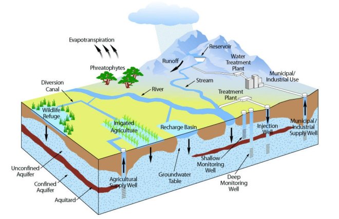
Groundwater’s Vital Role
Groundwater sustains over 35% of global water withdrawals, providing half the planet’s drinking water and 40% of water for irrigation (Dӧll et al., 2012). It also maintains stream baseflow, wetlands and springs – critical ecosystems and biodiversity hotspots. For example, groundwater accounts for over 50% of total flow in one-third of US streams and up to 90% during droughts (Barlow & Leake, 2012).
“Without reliable groundwater reserves recharged by precipitation, regions face ecological disasters, food insecurity and economic impacts as surface water sources dry up.“
Population growth, agricultural expansion and development drive increasing demands for groundwater. But governance challenges like unregulated pumping allow extraction to exceed sustainable yields in many aquifers. California’s San Joaquin Valley lost 140 cubic kilometers of groundwater from 1920 to 1970 as irrigation rapidly expanded, largely unchecked (Faunt, 2009). The advent of deep well pumping technology enables users to continuously draw down aquifers well beyond natural recharge rates.
But perpetual overdraft is not sustainable. The environmental bills eventually come due as interconnected surface waters suffer. We must expand monitoring and management to balance use with recharge – before aquifers are pumped dry.
Mechanisms of Groundwater Depletion
Excessive pumping triggers three primary mechanisms that damage connected surface water systems:
- Reduced Groundwater Discharge
- Diminishes baseflow in streams, wetlands and springs
- Induced Infiltration
- Reverses gradients, capturing surface water for aquifer recharge
- Water Quality Degradation
- Salinization, reduced dilution and contaminant mobilization
As water tables decline, groundwater discharge to surface waters follows suit. But pumping also initiates ‘induced recharge’ – essentially siphoning water from streams, lakes and wetlands into depleted aquifers (Barlow & Leake, 2012).
These changes degrade water quality too. Saline intrusion, geogenic contaminants and pollutants become more concentrated in shrinking surface waters. And lowered water tables enhance downward migration of contaminants from the surface into aquifers.
These complex interactions show why conjunctive monitoring and management of hydrologically connected groundwater and surface water is so crucial.
Impacts on Streamflow
“A river seems a magic thing. A magic, moving, living part of the very earth itself.” – Laura Gilpin
Groundwater discharge accounts for 60%-90% of streamflow in some watersheds (Barlow & Leake, 2012). But groundwater pumping diminishes this vital baseflow. A global survey of watershed models found streamflow declines averaging 40% in intensively pumped aquifers, with variability from 0%-100% (Li et al., 2020).
Impacts grow over time as pumping progressively captures baseflow that would otherwise sustain rivers and aquatic ecosystems. Modeling studies estimate streamflow reductions of 20%-50% across heavily depleted aquifers:
| Location | Estimated Baseflow Reduction |
|---|---|
| High Plains Aquifer, USA | Up to 50% |
| Upper Ganges Aquifer, India | 60%-70% since 1960s |
| North China Plain | 50% since 1960s |
| Murrumbidgee Basin, Australia | ~30% |
Lower flows increase temperatures, decrease oxygen and disrupt native biodiversity – degrading habitats and ecosystems. For example, streamflow declines have reduced riparian cover over nearly 50% of Arizona’s San Pedro River, threatening migratory birds that nest in the disappearing riverside forests (Leenhouts et al., 2006). The scale of damage will only grow as pumping outpaces recharge across aquifer systems worldwide.
Impacts on Ecosystems
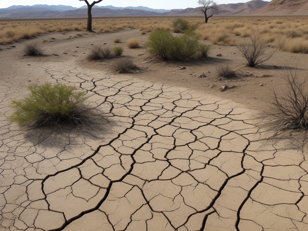
Groundwater depletion also threatens ecosystems at the surface. Wetlands, springs, rivers, lakes and vegetation rely on groundwater levels and discharge. But excessive pumping of aquifers can permanently damage these groundwater-dependent ecosystems.
Shrinking surface waters illustrate the impacts. California’s Central Valley has lost over 90% of its historical wetland area to pumping, drainage efforts and land conversion (Cameron et al., 2014). McLean County in the overdrafted High Plains Aquifer lost 62% of its wetlands from 1950-1980 (McGuire, 2017). Riparian forests have declined across rivers from Arizona to China as baseflows decline.
Riparian vegetation shifts from phreatophytes like willows and cottonwoods dependent on shallow water tables towards drought-tolerant xeric species like sagebrush. For example, repeat photography along Colorado’s Arikaree River showed lush galleries of trees in 1935 replaced by bare banks in 2008 due to over 30 meters of pumping-induced water table drawdown (Zeigenfuss et al., 2015).
These habitat changes ripple through ecosystems. Declining wetlands threaten waterbirds and migratory waterfowl that rely on them for breeding and migration stopovers. Disrupted river ecosystems impact fish, insects and all species interconnected in the aquatic food web. Groundwater depletion leaves a wake of environmental degradation across surface waters.
Water Quality Deterioration
Groundwater depletion degrades both surface water and groundwater quality through four key mechanisms:
- Saltwater Intrusion in coastal aquifers
- Contaminant Mobilization – arsenic, uranium, fluoride
- Reduced Dilution Capacity in shrinking surface waters
- Enhanced Surface-Groundwater Pollution Exchange
Saltwater intrusion leads to unusable wells and aquifers across the Mediterranean, India, Australia and many other pump-depleted coastal regions (Wada et al., 2010). Geogenic contaminants like arsenic and uranium increasingly taint groundwater from Asia to the United States (Burgess et al., 2010).
Shrinking surface waters see pollutant concentrations spike as their dilution capacity dwindles. For example, groundwater depletion has increased salinity levels in Iran’s Lake Urmia 6-fold (AghaKouchak et al., 2015).
Lastly, depleted aquifers are more vulnerable to downward seepage of pollutants from the surface – from fertilizers to industrial chemicals – as lowered water tables increase hydraulic gradients. Contaminants then discharge into surface waters or taint pumping wells.
Groundwater depletion thus degrades both groundwater and surface water quality through physical and biogeochemical shifts in aquifers. The cross-contamination underscores the need for holistic water quality monitoring and protection.
Case Examples Around the World
| Location | Depletion Impact |
|---|---|
| High Plains Aquifer, USA | Over 50% saturated thickness lost; baseflow decreased 20%-50%; saline intrusion |
| San Joaquin Valley, California | River flow reduced 75%; 95% wetland loss |
| North China Plain | Aquifer overdraft; 50% streamflow decline since 1960s |
| Upper Ganges Aquifer, India | 45 km3/yr pumping by 2000; 60%-70% river flow loss |
| Murrumbidgee Basin, Australia | Approx. 30% streamflow decline from pumping |
Hotspots like the High Plains Aquifer and California’s Central Valley show how chronic overdraft threatens interconnected ground and surface waters alike. But even aquifers traditionally considered “safe” face risks from increasing pumping as populations grow and agriculture expands. We cannot continue blindly draining finite groundwater reserves without consequences.
Factors Influencing Severity of Impacts
The severity of groundwater depletion’s impacts depend on:
- Depth to groundwater – Shallow aquifers have higher connectivity
- Aquifer properties – Transmissivity and porosity affect discharge
- Confining layers – Aquitards disconnect surface and groundwater
- Stream size – Larger rivers more connected than small headwaters
- Flow regime – Intermittent streams seasonally disconnect
- Land and water use – Agriculture and urbanization modify recharge
- Pumping intensity – High density causes rapid local drawdown
- Climate – Arid regions are highly susceptible to depletion
Considering these factors helps diagnose vulnerability and anticipate impacts. Heavily irrigated agricultural regions underlain by productive aquifers, like parts of the High Plains, face high risks. But even arid areas tap non-renewable fossil groundwater reserves, banking water supplies for the future.
We must pursue more nuanced accounting of water budgets, differentiating ground and surface water domains. Only then can we manage aquifers sustainably without sacrificing the streams, springs and wetlands that groundwater sustains.
Monitoring and Managing Depletion
Conjunctive monitoring and management of surface water and groundwater remains more vision than reality in most regions (Nelson & Perrone, 2016). Progress requires expanding monitoring networks and models to track depletion’s diffuse impacts. But no single tool suffices:
- Stream gages show surface water trends but cannot isolate groundwater effects
- Groundwater wells monitor subsurface levels and quality
- Remote sensing indicates regional changes in water storage, subsidence, and groundwater use (Famiglietti, 2014)
- Tracers using chemistry, DNA, temperature and isotopes help map connections (Kreamer & Hodge, 2018)
- Integrated models assimilate data streams, merging process representations with broad spatial coverage (Condon & Maxwell, 2014)
| Monitoring Approach | Information Provided | Limitations |
|---|---|---|
| Stream gages | Surface water variability and trends | Isolating groundwater effects difficult |
| Groundwater wells | Water table levels; water quality | Sparse coverage; clustered near pumping |
| Remote sensing | Regional storage; land subsidence; irrigation extents | Inferring aquifer conditions remains challenging |
| Tracers (geochemical, DNA, etc.) | Surface-groundwater mixing | Sample collection often limited |
| Integrated models | Spatial coverage; predictive capacity | Data assimilation and parameterization complex |
These advances must complement governance reforms that transcend fragmented management structures. As Aldo Leopold wisely stated: “A thing is right only when it tends to preserve the integrity, beauty and stability of the community.” Transforming policies to sustainably integrate ground and surface waters will prove as vital as advancing scientific capabilities (Nelson & Perrone, 2016).
Integrated Management: The Path Forward
Outdated legal frameworks that segregate ground and surface waters governance continue to hinder comprehensive management (Nelson & Perrone, 2016). But it is imperative we transition to integrated, cooperative policies that align human water needs with ecosystem requirements:
- Monitor aquifer health using conjunctive surface water data
- Model surface-groundwater connections to fill data gaps
- Manage pumping sustainably to balance competing demands
- Regulate groundwater and surface water extraction jointly
- Transform policies to enable cooperative governance across the hydrologic cycle
We cannot afford to view groundwater in isolation or ignore its interconnections with surface water systems. Aldo Leopold captured this eloquently:
“A thing is right when it tends to preserve the integrity, stability and beauty of the biotic community. It is wrong when it tends otherwise.“
Only by pursuing both scientific understanding and policy modernization can we achieve sustainable and ethical management of the imperiled freshwater systems we depend on. The hidden crisis of groundwater depletion makes transforming governance no longer optional, but an imperative.
References
AghaKouchak, A. et al. (2015). Aral Sea syndrome desiccates Lake Urmia: Call for action. Journal of Great Lakes Research. 41(1).
Barlow, P.M. & Leake, S.A. (2012). Streamflow depletion by wells-Understanding and managing the effects of groundwater pumping on streamflow. U.S. Geological Survey.
Burgess, W.G. et al. (2010). Vulnerability of deep groundwater in the Bengal Aquifier System to contamination by arsenic. Nature Geoscience. 3(2).
Cameron, D.R. et al. (2014). Whither the rangeland?: Protection and conversion in California’s rangeland ecosystems. PLoS One. 9(8).
Condon, L.E. & Maxwell, R.M. (2014). Evaluating the relationship between topography and groundwater using outputs from a continental‐scale integrated hydrology model. Water Resources Research. 50(8).
Dӧll, P. et al. (2012). Impact of water withdrawals from groundwater and surface water on continental water storage variations. Journal of Geodynamics. 59.
Famiglietti, J.S. (2014). The global groundwater crisis. Nature Climate Change. 4(11).
Faunt, C.C. (2009). Groundwater availability of the Central Valley Aquifer, California. US Geological Survey.
Kreamer, D.K. & Hodge, V.F. (2018). Half-century changes in California’s groundwater quality. Environmental Research Letters. 13(2).
Leenhouts, J.M. et al. (2006). Hydrologic requirements of and consumptive ground-water use by riparian vegetation along the San Pedro River, Arizona. US Geological Survey.
Li, D. et al. (2020). Quantitative synthesis of anthropogenic depletion and augmentation of global river discharge. Nature Sustainability. 1-8.
McGuire, V.L. (2017). Water-level and recoverable water in storage changes, High Plains aquifer, predevelopment to 2015 and 2013–15. US Geological Survey.
Nelson, R.L. & Perrone, D. (2016). Local groundwater withdrawal permitting laws in the South-Western US: California in comparative context. Groundwater. 54(6).
Wada, Y. et al. (2010). Global depletion of groundwater resources. Geophysical Research Letters. 37(20).
Zeigenfuss, L.C. et al. (2015). Shallow groundwater response to forest harvest: Implications from a coupled model and field study. Ecohydrology. 9(4).